Wednesday 26 September 2012

Prague

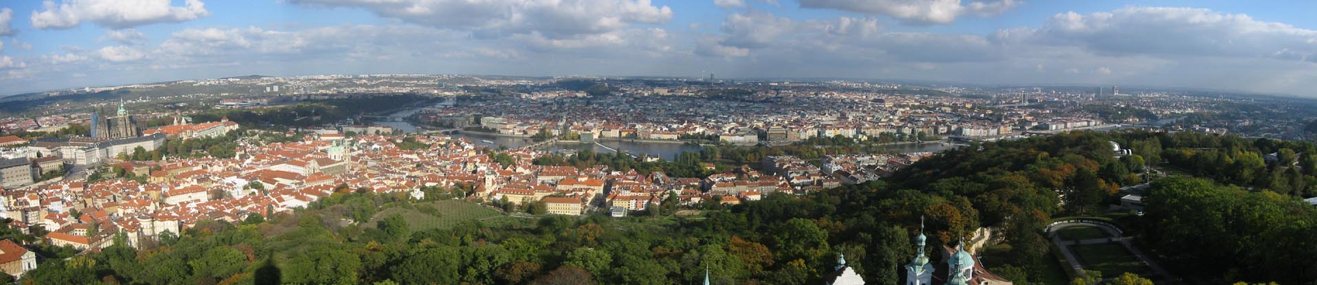
Prague is the capital and largest city of the Czech Republic. It is the fourteenth-largest city in the European Union. It is also the historical capital of Bohemia proper. Situated in the north-west of the country on the Vltava river, the city is home to about 1.3 million people, while its larger urban zone is estimated to have a population of nearly 2 million. The city has a temperate oceanic climate, with warm summers and chilly winters.
Prague has been a political, cultural, and economic centre of central Europe with waxing and waning fortunes during its 1,100-year existence. Founded during the Romanesque and flourishing by the Gothic and Renaissance eras, Prague was not only the capital of the Czech state, but also the seat of two Holy Roman Emperors and thus then also the capital of the Holy Roman Empire.

Nicknames for Prague have included "city of a hundred spires", "the golden city", "the Paris of the Twenties in the Nineties", the "mother of all cities", and "the heart of Europe". Since 1992, the historic center of Prague has been included in the UNESCO list of world heritage sites.
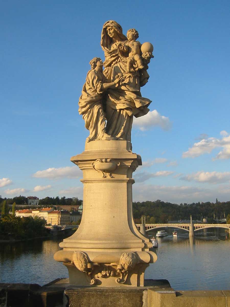
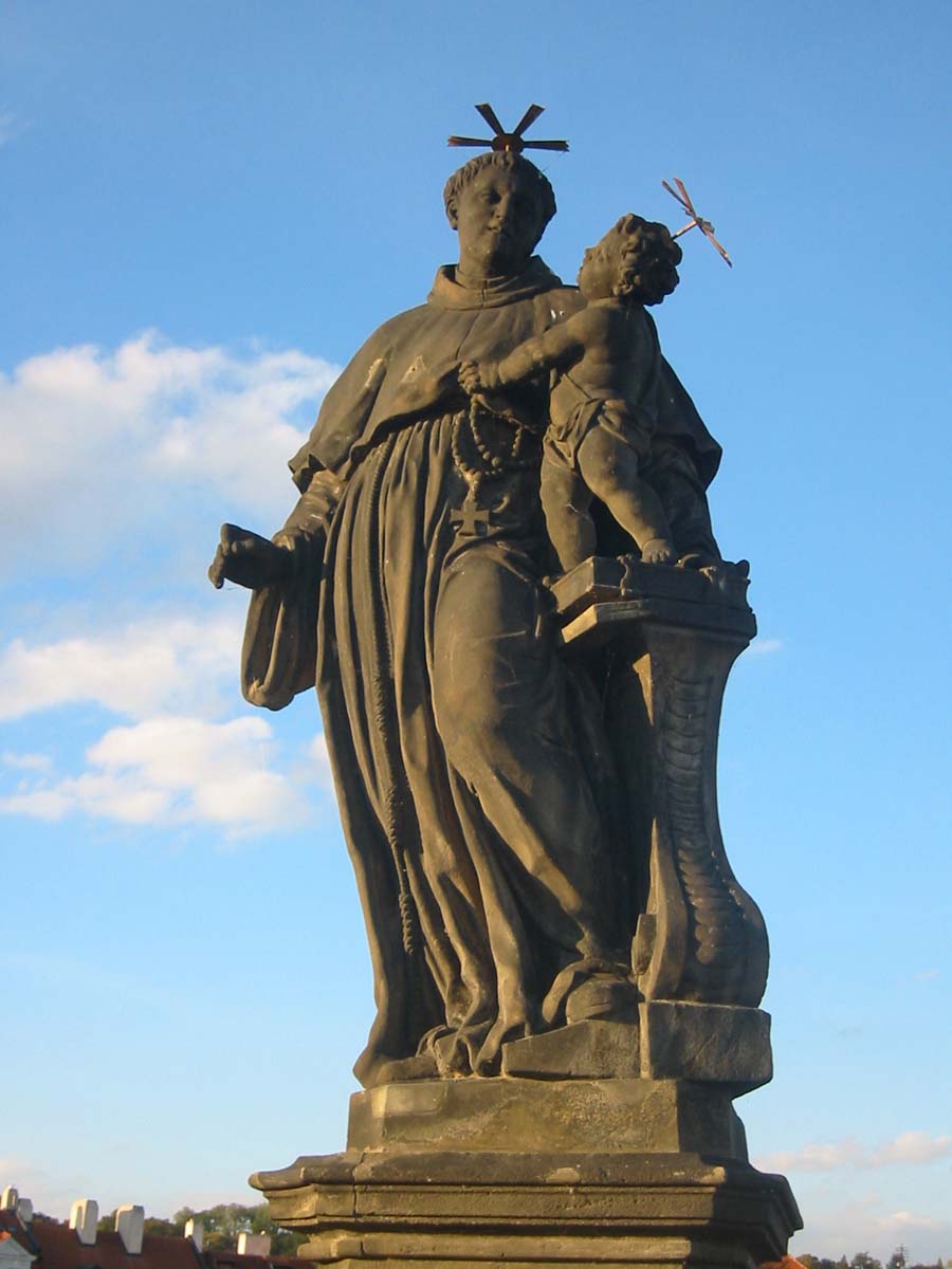
Prague is a popular tourist destination. There are lots of old buildings, many with beautiful murals on them. It contains one of the world's most pristine and varied collections of architecture, from Art Nouveau to Baroque, Cubist, Gothic, Neo-Classical and ultra-modern.


Tuesday 11 September 2012

ELECTROINFO -Project ,seminar,solution

ELECTROINFO -Project ,seminar,solution: Download Electronic Project , Seminar , Circuit Schematic capture with source code, Electronic Solution and Study Material.

THE SALAR UYUNI - BOLIVIA


DESERT OF SALVADOR DALÍ "POTOSÍ - BOLIVIA"


DESERT OF SALT IN THE NIGHT . SPLITS 2 "POTOSÍ - BOLIVIA"


AMAZONAS IN CHIQUITOS "SANTA CRUZ - BOLIVIA"


Cochabamba is a city in central Bolivia, located in a valley bearing the same name in the Andes mountain range. It is the capital of the Cochabamba Department and is the fourth largest city in Bolivia with an urban population of 608,276 (2008) and a metropolitan population of more than 1,000,000 people. The name derives from a compound of the Quechua words qucha, meaning "lake", and pampa, "open plain".Residents of the city and surrounding areas are commonly referred to as Cochabambinos. Cochabamba is known as the "City of Eternal Spring" and "The Garden City" due to its spring-like temperatures year round. It is also known as "La Llajta", "town" in Quechua.
The city is also host to the first World People's Conference on Climate Change and the Rights of Mother Earth.


Laguna Colorada (Red Lagoon) is a shallow salt lake in the southwest of the altiplano of Bolivia, within Eduardo Avaroa Andean Fauna National Reserve and close to the border with Chile.
The lake contains borax islands, whose white color contrasts with the reddish color of its waters, which is caused by red sediments and pigmentation of some algae.


DESERT OF SALT MAS BIG OF THE WORLD "UYUNI - BOLIVIA"


Uyuni is a city in the southwest of Bolivia. It primarily serves as a gateway for tourists visiting the world's largest salt flats, the nearby Salar de Uyuni.
Founded in 1890 as a trading post, the town has a population of 21,400 (2010 official estimate). The town has an extensive street-market. It lies at the edge of an extensive plain at an elevation of 3,700 m (12,139 ft) above sea level, with more mountainous country to the east.
There is little agriculture in the area because water supplies are scarce and somewhat saline. Today the town's primary function is as a gateway for tourists visiting the world's largest salt flats - the Salar de Uyuni. Each year Uyuni receives approximately 60,000 visitors from around the globe. The city also acts as a gateway for commerce and traffic crossing into and out of Bolivia from and to Chile, and there is a customs and immigration post downtown.

Train cemetery
One of the major tourist attractions of the area is an antique train cemetery. It is located 3 km outside Uyuni and is connected to it by the old train tracks. The town served in the past as a distribution hub for the trains carrying minerals on their way to the Pacific Ocean ports. The train lines were built by British engineers who arrived near the end of the 19th century and formed a sizable community in Uyuni. The engineers were invited by British-sponsored Antofagasta and Bolivia Railway Companies, which is now Ferrocarril de Antofagasta a Bolivia. The rail construction started in 1888 and ended in 1892. It was encouraged by the then Bolivian President Aniceto Arce, who believed Bolivia would flourish with a good transport system, but it was also constantly sabotaged by the local Aymara indigenous Indians who saw it as an intrusion into their lives. The trains were mostly used by the mining companies. In the 1940s, the mining industry collapsed, partly due to the mineral depletion. Many trains were abandoned thereby producing the train cemetery. There are talks to build a museum out of the cemetery.


Monument to Our Lady of Peace


The Monument to the Virgen de la Paz is a colossal sculpture commemorating the Virgin Mary , made ​​entirely of concrete, built 11 kilometers southwest of the city of Trujillo in Venezuela with 46.72 meters high, 16 meters wide, 18 deep at the base and about 1200 tons, is the tallest habitable sculpture America , being inches taller than the Statue of Liberty .
The monument is located, and at an altitude of 1,600 m in the call Rock of the Virgin , where it is said that the Virgin appeared in the year 1570 - and therefore the height of the work itself, together with the its enclave of mountains and tropical vegetation , providing a spectacular panoramic view of the region  was inaugurated in December 1983 by the then President of Venezuela Luis Herrera Campins , work designed by sculptor Manuel de la Fuente and engineering calculations Rosendo Camargo  has five balconies, from where you can see, on a clear day, almost all of the Trujillo State , part of the Sierra Nevada de Mérida and the South Coast of Lake Maracaibo
Since 1568 the Virgin of Our Lady of Peace is the spiritual patron of Trujillo and is also patron of the diocese since 1960. The dove held in his right hand symbolizes the task of the presidency of the Republic of Venezuela, to cry for peace on earth.  The Monument to the Virgen de la Paz, was managed for years by a private foundation, after which he became headed by the Governor of the state of Trujillo.
Very despite its huge size and the importance of their symbolism commemorating the patron state, the Memorial of Our Lady of Peace is one of the least visited of contemporary tourism in Trujillo and country. At Easter 2010 the Trujillo government reported 11,000 visitors to the memorial of Our Lady of Peace, while the sanctuary of José Gregorio Hernández in the neighboring municipality Rafael Rangel , received nearly 80,000 visits and traditional population Viacrucis of Tostos , was visited by an estimated 57,000 tourists.


Cristo de la Concordia is a statue of Jesus Christ located on San Pedro hill in Cochabamba, Bolivia. The statue is 34.20 metres (112.2 ft) tall, on a pedestal of 6.24 metres (20.5 ft), bringing its total height to 40.44 metres (132.7 ft). The statue is slightly larger than Christ the King in Świebodzin (if the 2 metres (6.6 ft) high crown of Christ the King is not counted) and Christ the Redeemer in Rio de Janeiro, making it the largest statue of Jesus Christ in the world. It is the third largest statue in the Southern Hemisphere, after the statue of Virgen de la Paz, Venezuela and the statue of Saint Rita of Cascia in Brazil.


Nabusimake, Cesar

Old Native American town, main seat of the Arhuaco Indigenous people. Based at the southern foothills of the highest coastal mountains in the world, the Sierra Nevada of Santa Marta on Colombia's Caribbean coast.


Tintipan Island, San Bernardo Archipelago, Sucre

Sierra Nevada del Cocuy, Boyaca

The Sierra Nevada del Cocuy Chita o Guican National Natural Park (or Sierra Nevada de Chita or Sierra Nevada de Güicán,SpanishParque Natural Sierra Nevada del Cocuy Chita o Guican is a national park and a set of highlands within the Cordillera Orientalmountain range in the Andes Mountains of Colombia.


Chingaza National Park is located in the Eastern Cordillera of the Andes, in the northeast of BogotaColombia in the departments ofCundinamarca and Meta. The elevation ranges from 800 to 4,020 meters, and the temperature ranges from 4 °C to 21.5 °C.


Lake Otún


Lake Otún (Laguna del Otún) is a small lake in the Nevados National Park, in the Risaralda department of Colombia. It located at an altitude of 3,900 m and has an area of 1.5 square kilometres. The lake is of glacial origin and is fed by meltwaters of the Nevado Santa Isabel. Lake Otún is the source of the Otún River, which supplies drinking water to the cities of Pereira and Dosquebradas.
Lake Otún is an important breeding ground for several threatened or endangered bird species, including the Colombian Torrent Duck (Merganetta armata columbiana), the Colombian Ruddy Duck (Oxyura jamaicensis andina), the Andean Teal (Anas andium) and the Andean Snipe (Gallinago jamesoni).[1]
Lake Otún contains a large population of rainbow trout, introduced for recreational fishing and a major attraction for visitors to the lake


Guatapé is a town and municipality in Antioquia DepartmentColombia.[1] Part of the subregion of Eastern Antioquia. Guatapé is located in the outskirts of Medellín, bordering a reservoir created by the Colombian government for a hydro-electric dam, built in the late 1960s. This quaint town is the gathering place for "Las Vegas", or the small farms of the area. It is also a growing area of recreation for citizens of Medellín, and aims to be a tourist destination for foreign travellers.
Guatapé was founded in 1811, by the Spaniard Don Francisco Giraldo y Jimenez. The name "Guatapé", comes from the Quechua language, related to "stones and water". The area was visited by the conquistadors circa 1551.[2]

View from the rock
On the late 20th century, Guatapé became one of the most important electric production centers in the country, the guerrilla later initiated operations, trying to black mail the local power company, and farm owners, later, the paramilitaries began operations. The Antioquian and national government sent security forces into the area in force to crush the paramilitary that once controlled the area. By 2006, the remaining military and police presence has diminished drastically. With no paramilitary activity remaining in the area, the national police presence is now only necessary to ensure that they do not return.
New resorts, several restaurants, and rental homes along the lake are available for visitors. Each building has tiles along the facade's lower walls in bright colors and dimensioned images. Many of the tiles are tied to the products sold by the shops, or the beliefs of the residents. Others are cultural images of the farming heritage of the community.


Monday 10 September 2012

Caño Cristales is a Colombian river located in the Serrania de la Macarena, province of Meta. The river is commonly called "The River of Five Colors," "The Liquid Rainbow" or even "The Most Beautiful River in the World" due to the algae produced colors like red, yellow, green and blue at the bottom of the river giving it a unique appearance.


A unique biological wonder, Caño Cristales has been referred as the "river of seven colors," "the river that ran away from paradise," and "the world's most beautiful river."
For most of the year, Caño Cristales is indistinguishable from any other river: a bed of rocks covered in dull green mosses are visible below a cool, clear current.
However, for a brief period of time every year, the river blossoms in a vibrant explosion of colors. During the short span between the wet and dry seasons, when the water level is just right, a unique species of plant that lines the river floor called Macarenia clavigera turns a brilliant red. It is offset by splotches of yellow and green sand, blue water, and a thousand shades in between.
This only happens for a brief period in between seasons. During Colombia's wet season, the water flows too fast and deep, obscuring the bottom of the river and denying the Macarenia clavigera the sun that it needs to turn red. During the dry season there is not enough water to support the dazzling array of life in the river. But for a few weeks from September through November, the river transforms into a veritable living rainbow.
Caño Cristales is located in a remote, isolated area not easily accessible by road. Adventurous tourists can now fly into the nearby town of La Macarena. From there it is a short trip into "Serrania de la Macarena," the national park in which Caño Cristales is located.
The site was effectively closed to tourists for several years because of guerrilla activity in the region along with concerns about the impact of unregulated tourist traffic. It was reopened to visitors in 2009, and today there are several Colombian Tourist Agencies that will fly travelers to La Macarena. From there, they must make their way to the river site on horseback (or donkeyback) and by foot as part of a guided tour. Visitors are not permitted to stay overnight or cook.